
Davos Klosters & Rhine Valley route
3 Bilder anzeigen
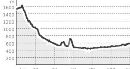
On this route, you will get to know Eastern Switzerland and the Graubünden Rhine Valley with its wine villages, the Graubünden Herrschaft. In addition to good wines in the Torkel, the region is also known as Heidiland. Discover the world-famous story "Heidi" by Johanna Spyri in the authentic Heidi village, surrounded by an impressive mountain landscape. In the Heidi village above Maienfeld, experience an emotional journey back to the Swiss mountain world of the late 19th century and learn how Heidi lived.
Distance: 183 km
Travel time: 3.45 h
Details
Beschreibung
To get to the Graubünden Rhine Valley, drive from Davos along the Prättigau to Landquart. In Landquart, it is better to take the country road so you can drive through the Graubünden Herrschaft with its villages Malans, Jenins, Maienfeld, and Fläsch, through the magnificent, sun-soaked vineyards. In Fläsch, the road leads up to St. Luzisteig. A small pass that connects Graubünden with the Principality of Liechtenstein. Via Buchs, Sevelen, and Bad Ragaz, it goes back to Landquart from where you can follow the Rhine along the villages of Trimmis and Zizers to Chur. From Chur, it goes windingly up to Lenzerheide. The route leads via the neighboring community of Lenz along the Landwasser, past the old Walser settlements back to Davos.
Geheimtipp
At the Arkadenplatz, the cultural square in Davos, end the day with a Monstein beer and reminisce about the unforgettable moments of the motorcycle ride.
Wegbeschreibung
Davos - Landquart - Fläsch - St. Luzisteig - Vaduz - Schaan - Buchs - Sevelen - Bad Ragaz - Landquart - Chur - Churwalden - Lenzerheide - Lenz - Schmitten - Davos
Anfahrt
Parken
Public parking lots/parking garages in Davos


Verantwortlich für diesen Inhalt Destination Davos Klosters.

Diese Webseite nutzt Technologie und Inhalte der Outdooractive Plattform.