
Uphill Hörnli
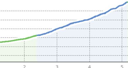
Steep ascent from the Weisshorn mid-station to the Hörnli-Express summit station.
Details
Beschreibung
The ascent takes place via a forest road and requires endurance and sufficient leg strength from the Carmennahütte to the summit station.
Geheimtipp
Get the Bike Kingdom App – your digital trail buddy on the go! With live data, challenges, and navigation. Download now for free and get even more out of your ride.
Sicherheitshinweis
Mountain biking in alpine terrain carries risks.
- Important emergency numbers are:
- 144 emergency, first aid
- 1414 mountain rescue REGA
- 112 international emergency number
The Bike Kingdom offers a place for everyone. Be a Bike Knight and respect trail tolerance. Hikers and bikers share the trails and consider each other.
Ausrüstung
Wear your gear! Helmet, protectors, and bike gloves are standard equipment. You might also be glad to have sun and rain protection as well as some water.
Anfahrt
Öffentliche Verkehrsmittel
Arrival from Chur by regional train to Arosa
Anreise Information
Access via the A13 to Chur, then via the cantonal road to Arosa
Parken
In Arosa village.


Verantwortlich für diesen Inhalt Arosa Lenzerheide.

Diese Webseite nutzt Technologie und Inhalte der Outdooractive Plattform.